The ethnographic Trail
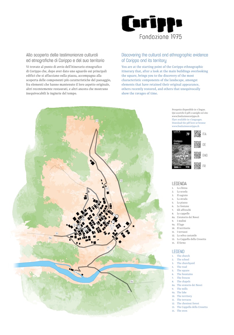
If you are not satisfied by taking only a quick look at Corippo whilst passing on the opposite side of the Verzasca, you can walk the short path that from the bus stop leads to the village square in about fifteen minutes*. There, an InfoPoint provides a brief introduction to the natural landscape and the settlement, and outlines the reasons that led to the creation of the Fondazione Corippo 1975 and its main projects. It also marks the starting point of the ethnographic itinerary that, after a look at the main buildings overlooking the square, brings you to the discovery of the most characteristic components of the landscape, amongst elements that have retained their original appearance, others recently restored, and others that unequivocally show the ravages of time.
* Given the very limited number of parking spaces, access by private vehicles is strongly discouraged
View or download the flyer here
- The church
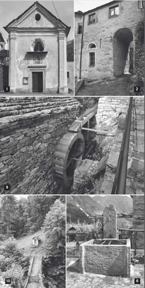
Consecrated in 1614, the church is dedicated to the Blessed Virgin of Carmel. The current structure is the result of several interventions including, in particular, an extension dating back to the last decades of the 18th century, when the parish became independent from Vogorno. Inside, on the left side remains a fragment of a Last Supper, already mentioned in 1703.
A large room under the choir served, between 1770 and 1850, for the burial of the dead.
For several years now, during the Christmas period, the small church has been embellished with an imposing crib that occupies the entire chapel dedicated to St. John the Baptist, on the right side of the building, attracting many visitors.
- The school
Following the left wall of the church, you find yourself in front of the sacristy above which a room was built to house the school. Around the middle of the 19th century, when Corippo reached over 300 inhabitants, it was decided to expand the building by joining it to the house located upstream. The arch under the new construction provides the main access to the village, which was originally only above the church.
- The churchyard
Up to the mid 1800s, the area that is now the square was used for interments. This practice, like the burial of the dead in the church mentioned above, was banned by the cantonal authorities in 1831. About two decades later, and because of the difficulty of finding an adequate location to house a cemetery, Corippo was one of the last municipalities in Ticino to comply with this legislation.
- The road
Since the Middle Ages, the main transit route of Verzasca runs along the left side of the valley, leaving Corippo isolated. Even the road that reached Sonogno in 1873 did not originally provide a direct access to the village, which was finally built only in 1884, thanks to the insistent pressure exerted by the municipality before the cantonal authorities.
Linking the road to the heart of Corippo led to the definitive transformation of the space that had housed the churchyard and to the displacement of the funerary column that had been laid there in 1715 and is now in the cemetery.
- The square
In addition to the buildings mentioned so far, the parish house (on the side overlooking the valley) and the tavern (which is the central element of the Albergo diffuso) overlook the square. Leaning against the bell tower lies a building that was built between 1791 and 1794: it has changed its appearance, in particular by the addition of the porch, and its function several times over the centuries: it was first an ossuary, then a municipal house, and finally a patrician house.
- The fountains
Leaving the square and its fountain behind, you enter the nucleus, which is immediately characterised by the high density of buildings. After a few steps, you will find the second of the four stone fountains located along the path, all of them being built in 1879 as indicated by the date engraved on each one of them.
The itinerary then leads you through the alleys nestled between houses, alternating between paths across the slope and stairs following it. When you reach the upper part of the settlement, turn left and continue towards another fountain.
- The frescos
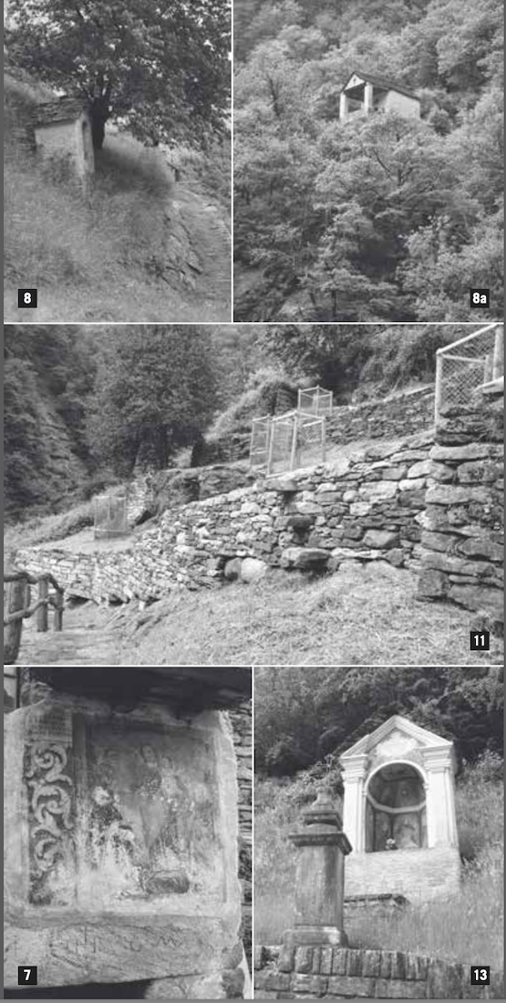
In rapid succession, you will find three frescoes devoted to the figures of the Virgin and Child. The blackened face of the Madonna depicted on the framed image is just one of the many signs left by time on these witnesses of the deep religiosity of the past, which today appear largely deteriorated or even illegible.
Going back, you now leave the nucleus to enter the Corippo Valley.
- The chapels
At the three main entrances to the village stand as many chapels, all recently restored. The niche you will find at the entrance of the path that leads to the mountains dates back to 1764 and houses an image of the Immaculate Madonna crushing a snake.
8a. The oratorio dei Novei
To reach the place known as Novei, you must leave the main route and face a steep climb of about 15 minutes. Along the way, it is worth taking a glance at the stairs that were built with impressive stone steps. The small oratory, usually closed, is dedicated to Our Lady of Grace and is a pilgrimage destination during the days preceding the patron feast, which is generally celebrated on the third Sunday of July.
- The mills
Approaching the stream Lavadosa, the grinders aligned on the ground reveal the presence of two mills that were fed by the same channel. The mechanical part, the structure, and the surrounding area of the most upstream mill have recently been restored. It is now fully operational and is used for demonstration purposes few days throughout the year. It is possible to arrange visits by contacting the Fondazione Corippo 1975 (info@fondazionecorippo.ch). Crossing the stone bridge, probably dating back to the 17th-18th century, you enter the path that connects Corippo to Mergoscia. Here you can find, as mentioned in point 8, a chapel built at one of the entrances to the village.
9a. The lake
At the crossroad, a deviation of about thirty minutes offers a wide panorama of the artificial basin. When the lake level is very low, you can still see the old road that ran through the Verzasca Valley and the remains of some buildings in the lower hamlets of the municipality of Vogorno, submerged in 1965 by the filling of the dam. The circular route then takes you back to the main route.
- The territory
Taking the path on the right at the crossroad after the chapel, you quickly reach a promontory on which lies the only flat area of Corippo. From there, the view sweeps over a large part of the municipality, allowing you to see very clearly its vertical development. In addition to the countless terraces that surround the main nucleus, there are several groups of buildings scattered along the slope; almost at the top of the mountain you can see Corgello, the highest settlement among the fifty that make up the village.
- The terraces
The construction of terraces made possible the farming in fields on a slope, otherwise unsuitable for cultivation. The main cropping involved hemp, present until the first decades of the 20th century, or cereals, which in 1940 still occupied a large part of the useful surfaces.
The recovery of some terraces has recently allowed the planting of some fruit trees.
- The chestnut forest
Another initiative to enhance the landscape has led to the restoration of a chestnut forest.
The interventions involved the removal of undergrowth vegetation and the pruning of chestnut trees on the downstream slope of the road.
Once widespread over a wide belt around the nucleus, chestnut trees played a central role in the food economy. For this reason, it was important to be able to preserve the fruits for a long time. The privileged method consisted of drying the chestnuts inside the so-called graa, subjecting them to the action of a fire that was kept lit for a few weeks. In the mid-19th century, there were nine such buildings scattered throughout the various settlements. The faithful reconstruction of a graa is one of the possible future projects of the Fondazione Corippo 1975.
- The Cappella della Crosetta
At the main entrance of the village lies the chapel with the richest architectural structure and paintings: a Pietà in the central part, St. John the Baptist in the company
of another unidentified saint on the right, St. Peter with the keys, St. Joseph on the left, and the Eternal Father on the vault. Already mentioned in 1629, the chapel has been restored several times.
In front of it, you can see the base of the funerary column that is now in the cemetery and can still read, albeit with difficulty, the engraving of the year 1715.
- The oven
Slightly above the road, there are two small buildings that once housed two ovens; one of these, which has the unusual feature of having the opening protected by the roof, has recently been restored to its original state. The location of these buildings reflects the customary use of relegating to the outskirts of the town the activities that involved the use of fire.
Before finishing your tour by returning to the square, the itinerary brings you to take a last look at the fresco, unfortunately in a very bad condition, located on a façade near the fountain, facing upstream. Dating back to the early decades of the 16th century, or according to other sources even to the 15th century, it is probably the oldest mural of Corippo.
Other ethnographic itineraries to discover the area are available starting from the website of the Verzasca Valley Museum